Climbing Mt. Kilimanjaro:
March 2000
Ascent via Machame Route; Descent via Mweka Route |
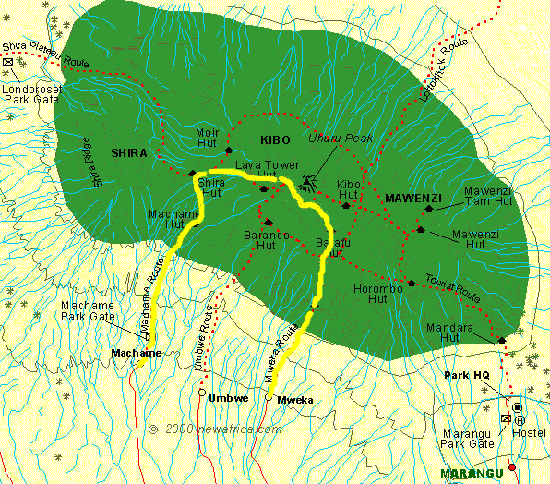
Machame Route is a rather steep ascend from the village of Machame (1450 m) to Shira Plateau and to the summit through the Western Breach. It is a very nice trail and not so overcrowded as many other trails.
It is a camping route, the few shelter huts are for the porters. The ascend of the steep trail starts in Machame and leads through the rain forest and Erica arborea zone to the camp Shira Plateau (3800 m). It is possible to camp at the upper tree line of the rain forest at about 3000 m. From the Shira Plateau one ascends to Arrow Hut (4900 m). It is not steep, but the altitude is high!! Arrow Hut is the last camp before the summit. The name, however, is misleading - the shelter hut got destroyed by falling rocks.
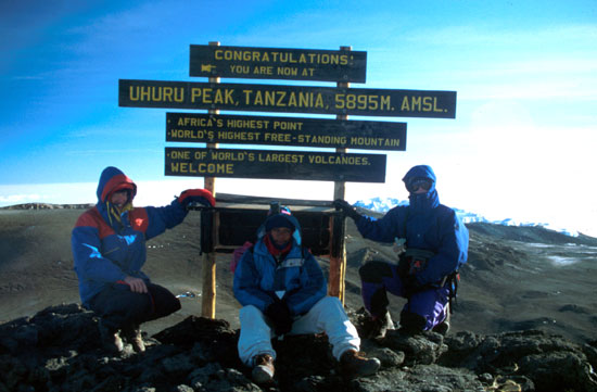
Usually the ascend to the summit is started around midnight. If there is no moon light, it is completely dark, and a good flashlight is helpful in finding the small track. There is a bit of climbing to do, but no rope is necessary. After about 4 h we reached the crater rim at Furtwangen Glacier. From there it is still about a 150 m ascend from the inner side of the crater rim to the summit - and it takes long... However, it is a very nice final ascend, allowing great views of the ash pit and the glaciers of the crater.
The descent via Mweka rout basically means running down the mountain on a direct line. The first 1000 m lead through a gravel field, basically sliding down on the gravel and small rocks. From the camp Barranco (about 4600m), the trail leads back to the Erica arborea zone, and to the Mweka camp at the beginning of the rain forest at 2800 m. (from the summit to there, we did a descend of 3000 m!). From the Meweka camp it is another 1300 m descent to the village of Mweka. Again the trail through the rain forest is very steep.
Topics
The Route
The Climb
Plants of Kilimanjaro
We did the tour in 3 and a half days, meaning direct ascend from Machame (1400m) to the Shira Camp (3800m) on the first day. On the second day the walk to the Arrow Camp (4900m). The third day started at midnight with the ascend to the summit (5895m) and was followed by a descend to the Mweka Camp (2800m). The fourth day basically was walking back to Mweka village (about 2-3 h).